If you're the kind of person who plans out every trip detail ahead of time, we belong to the same camp. Still, I build into my route several options for making unscheduled stops along the way, as I seem to do this a lot. I'm always surprised that people still use printed maps which are always out of date by the time you purchase them. (I know, I owned a publishing and printing company for 22 years)
The software doesn't require you to be on-line to use. I can select what roads to take or allow the device to do it (and I can modify if I want). Then I can ask to see what's along my route up for miles in every direction. If I have a question about a part of the route, I click on it and Google Earth opens and shows me an up-close satellite/street view. That part does need internet access, but its also allows me to place my destination or a stop (like Flying J) in the exact driveway I want to turn into. Most POI's are placed over the top of the store or a Flying J, and as you approach the busy location you need to search which driveway you are to turn into and hope your in the correct lane to do it.
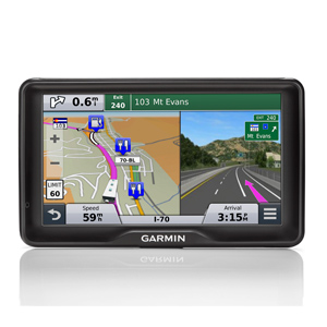
The route shows me how many miles I'll drive, how long it will take to drive, and the turn by turn instructions of what the lady on the GPS will say along the route. Free custom POI's added to Base Camp show me low-overhead clearances, weight restrictions, low hanging branches (haven't heard that warning yet) every restaurant, campground (most of them), store, truck stops, gas stations, medical, zoos, attractions...the list is endless.
I would never allow the GPS to select my route, and would NEVER drive anywhere without knowing what type of roads I was driving on before I left. With Garmin's Base Camp, I can (and did) plan a eight month trip from South Florida to Tucson, then up to Glacier National Park in Montana, crisscrossing back and forth through the Rockies between parks, and then back to South Florida, spending 4-10 days at each location. I'm just completing that route now. Each day of driving has its own route to use and I do make changes to some routes as I changed my mind along the way.
Once I complete a route I plug the GPS into my computer and send it to the device - done.
FYI - the new Garmin RV760 also tells you about low clearances, sharp turns, lateral wind warning areas, narrow bridges, risk of grounding, along with settings you can turn on like "no u-turns" "no unpaved roads" "no toll-roads" etc. You add a personalized profile to tell the device your rig's length, height, weight etc...
Maps are updated every 90 days for free by connecting your device to your computer and going to Garmin's web site. From on-line, plug into Base Camp it will tell you when there is an update available. With this, four times a year your maps are updated, not once a year with printed maps.
Check out Base Camp at http://www.garmin.com/en-US/shop/downloads/basecamp.
[Jason Bell is a fulltime RVer who travels in his 2013 40' Tiffin Phaeton. He joined the ranks of the retired six years ago. ]
Basecamp alone is reason enough to buy a Garmin GPS. I plot and tweak a route in basecamp and then download to the GPS unit. The learning curve for Basecamp was kinda steep - but well worth the educational effort.
ReplyDeleteFor route planning give the web based RVTRIPWIZRD.com a try. It is web based, lists thousands of campsites, allows you to prioritize campsite memberships and allows you to export your route to your GPS (in my case (Garmin DEZL). Great features ad the author updates the database constantly.
ReplyDeleteThere is an annual charge for the service but it is modest and it does require you have an internet connection to function.
Standard disclaimer - not affiliated with the company not making money on references