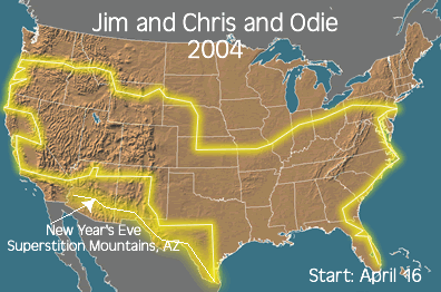
It started out as a simple graphic with a line to represent our travels, Then I started using Streets and Trips and taking a screenshot.
Then Google Custom Maps came along, now called Google My Maps. It’s free and really quite easy to make a map with lots of detail.
Samples of our Travel Maps
2004 | 2005 |
2010 | 2011 |
2013 | 2014 |
It has gotten more sophisticated over the years. Now, with the free Google My Maps, I can see the overview, but every marker is clickable and I can have pictures, videos and text that you see when you click a marker. You can see all 11 of our yearly maps on our Blog’s Map page.
2015 Travel Map
Here is our map for 2015 … over 10,000 miles in the RV, plus trips to Europe, Bahamas, and Cuba! If you click on the picture below, it will take you to the full map, then try clicking on individual markers – like Madison, Wisconsin, or Cienfuegos, Cuba. You will see photos and perhaps links to blog posts. What a fabulous way to record all the details of your travels in one place! |
| Now, using Google My Maps, every marker can tell a story. |
How to Make a Map
To use Google’s My Maps, you start with the regular Maps.Google.com. It’s best to use the Chrome browser, but not essential. What is essential is that you must be logged in to your Google Account. Check the upper right corner of your screen and see the circular icon – usually your face – that represents the account. If it’s not you, or it says, “Sign In” then click there and sign in with your Google account. Then click the 3-line menu, and then My Maps. You will then be able to open one of your existing maps, or create a new one.
Once you’re there, you’ll see a little toolbar.

To make a marker, you click on the 4th button over – the marker tool – then click the place in the map where it goes. That will open up a dialog box where you can add further information about that spot. To draw a line, you use the next button over, then drag on the map to create the line.
Your map is being saved automatically as part of your Google Account. There is also help available on the same menu.
Planning Ahead
Google My Maps is not the only way to do this, we like using the Roadtripper.com app and website to sketch out our plans.
I use Microsoft Streets & Trips - sadly no longer a supported program. My 2010 version, though works just fine. You can see it here: http://pastorscott.com/travel/2015-travel-map/
ReplyDeleteThanks Scott! Yes, we miss S&T also. I loved seeing all the Thousand Trails on your map. I remember meeting you at Verde Valley. Keep on Travelin!
ReplyDeleteChris, Thanks for the quick article. I publish a Blog of my winter RV travels. I have always tried to put an overview map in the beginning of the blog. I write the blog as we go along thus the map grows as we travel and post. What I want to do is keep the data on each stop in a spreadsheet and then build the map fresh from the spreadsheet. Google My Maps allows you to do that but I have never gotten it to work consistently from one publish to another. Here is the best I have done so far but it is not easy:
ReplyDeletehttps://www.google.com/maps/d/viewer?mid=z6Y13PTy67aw.kGO-ruNiczWM&usp=sharing
Cool!
ReplyDeleteYes, you can import spreadsheets of data to create a new Layer - I've found that to work pretty well. But, you can't add to that layer, you have to delete it and start over.
hmmmm, I wonder if you keep the spreadsheet in Google Docs if there's a way to make it dynamically update? Not that I know of, but it's worth a try.